Maadi, located in southern Cairo, has long been known as an upscale residential district distinguished by quiet streets, dense vegetation, and expansive gardens. Established in the early twentieth century, it was planned as a low-density suburb of spacious villas set within generous green plots. This design produced a distinctive aesthetic and attracted embassies, international schools, expatriates, and political and cultural elites, fostering a socially diverse and cosmopolitan community.
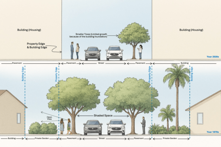
From the outset, Maadi embodied principles akin to the garden city philosophy, emphasizing balance between built form and nature, low density, and high-quality public space. Villas were integrated into the broader landscape through low boundary walls, extensive gardens, and tree-lined streets. The organic overlap between private and public greenery created shaded pedestrian corridors that encouraged walking and outdoor life. Planning respected natural topography, preserving slopes and vegetation patterns. The result was a harmonious environment that reinforced residents’ sense of belonging and daily engagement with nature.
Maadi’s relationship with the Nile was central to its urban identity. The river functioned not merely as scenery but as an extension of everyday life, connected through promenades, open views, and recreational use. The ‘Connecting Cairo to the Nile’ workshop identified Maadi as one of four key zones shaping Cairo’s riverfront relationship (Kondolf et al., 2011). Historically, the corniche offered accessible public space, minimal barriers, and unobstructed views, encouraging strolling, exercise, and social interaction. Vegetation, including ficus, jacaranda, palms, hibiscus, and duranta, reinforced this identity, while nearby Wadi Degla provided ecological continuity through desert biodiversity.
Scholars have documented Maadi’s development and transformation. DeVries (2021) traces its formation and early suburban vision, while Badawy, Abdel-Salam, and Ayad (2015) analyse the broader effects of urban planning policies on socio-spatial divisions in Cairo, including Maadi. Together, these works frame the district’s evolution within larger urban and political dynamics.
From a Green Suburb to a Concrete City
Since the 1990s, Maadi has undergone rapid urban transformation. Market-driven development, rising land values, and weak long-term environmental planning have reshaped its character. Villas surrounded by gardens have been demolished and replaced with multi-story apartment buildings, often constructed without setbacks. This shift has significantly reduced private green spaces and severed their visual and ecological connection to public streets.
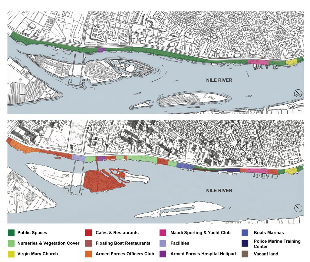
The Nile waterfront exemplifies this transition. In the 1970s, built structures occupied only a small percentage of the corniche, leaving most of the riverfront open and accessible. Today, a large proportion of the same stretch is occupied by commercial or enclosed uses. Mini-markets, restaurants, cafés, wedding halls, and institutional facilities increasingly dominate the frontage, frequently obstructing visual and physical access to the river. What was once a continuous public promenade has become fragmented and partially privatized.
Walkability has deteriorated. Sidewalks vary in width and quality, are often encroached upon by parked vehicles, and in some areas are reduced to narrow passageways. Inconsistent design and poor maintenance disrupt the pedestrian experience and weaken the connection between residents and the river. The corniche has shifted from a coherent public space to a disjointed strip shaped largely by commercial priorities.
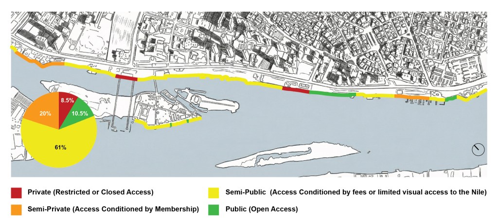
Access to the Nile is now stratified. Some areas require entrance fees; others require mandatory consumption at cafés or restaurants. Private clubs restrict entry to members, while certain institutional facilities limit access to affiliated personnel. Only a small portion of the riverfront remains freely accessible without financial or institutional conditions. This pattern reflects what Harvey (2008) describes as the restructuring of urban space in ways that constrain the ‘right to the city’, reinforcing socio-spatial inequality. Figure 1 displays a map that shows how the land use of the water bank has changed from the 1970 to date.
Similarly, the map in figure 2 illustrates the extent of accessibility along the riverfront, categorized as follows:
- Public: Areas that are freely accessible to everyone.
- Semi-public: Spaces that require a ticket purchase or a minimum fee for entry.
- Semi-private: Areas that are accessible through membership.
- Private: Stretches that are exclusively accessible to their respective owners.
Green cover has also declined over the years. The demolition of historic villas eliminated mature trees and gardens that once extended into public space, forming continuous canopy corridors. While some streets, such as Street 5 and El-Nahda Street, retain partial tree canopies, these are now exceptions rather than the norm. The reduction of vegetation not only alters aesthetics but also affects microclimate, biodiversity, and pedestrian comfort.
Civil society initiatives have emerged in response. Local groups advocate for tree preservation, organize clean-up campaigns, and document environmental violations. These grassroots efforts seek to defend what remains of Maadi’s ecological identity and to reassert community participation in shaping the district’s future.
Future Prospects
Maadi’s transformation raises fundamental questions about its identity. Once a model of suburban balance between urban form and nature, it increasingly reflects broader metropolitan trends toward densification, privatization, and profit-oriented land use. Public space has been fragmented, and the relationship with the Nile has shifted from open engagement to conditional access.
Reversing this trajectory requires coordinated action. Protecting remaining mature trees and preventing further loss of green cover must become planning priorities, not aesthetic afterthoughts. Clear urban and environmental policies, coupled with effective monitoring mechanisms, are necessary to counter unchecked real estate pressures. Community-led initiatives should be integrated into formal planning processes rather than treated as peripheral activism.
Safeguarding and rehabilitating the Nile waterfront is equally critical. Restoring accessible, continuous public space along the river would help rebuild Maadi’s historical relationship with nature and reinforce social equity. Design interventions should prioritize walkability, shade, and ecological sustainability, reconnecting fragmented green spaces into an integrated urban network.
Ultimately, Maadi’s future depends on reestablishing balance between development and environmental stewardship. Its history demonstrates the viability of a human-cantered, nature-integrated urban model. Whether it continues toward concrete density or reclaims aspects of its garden-suburb heritage will depend on policy choices, civic engagement, and a renewed commitment to the right of residents to access, shape, and inhabit their city.
This blog is based on Amir’s book chapter ‘Maadi: From Landscape City to Concrete City’ in Maadi: On the History and Culture of a Green Suburb, ed. Nezar AlSayyad, Professor Emeritus at UC Berkeley and sponsored by: National Organisation of Urban Harmony (NOUH)
Feature image: Book cover of Maadi: On the History and Culture of a Green Suburb
References cited in this blog
Badawy, A., Abdel-Salam, H. and Ayad, H., 2015. Investigating the impact of urban planning policies on urban division in Cairo, Egypt: The case of El-Maadi and Dar El-Salam. Alexandria Engineering Journal, 54(4).
DeVries, A., 2021. Maadi: The Making and Unmaking of a Cairo Suburb, 1878–1962. Cairo: American University in Cairo Press.
Gohar, A., 2018. Greening and Opening the Public Space of the Nile Banks: A Demonstration Case Study in Maadi, Cairo. The Journal of Public Space, 3(1).
Harvey, D., 2008. The Right to the City. New Left Review, 53, pp.23–40. Kondolf, G.M. et al., 2011.
Connecting Cairo to the Nile: Renewing Life and Heritage on the River. Working Paper No. 2011-06. Berkeley, CA: University of California, Institute of Urban and Regional Development (IURD).
View the article here.